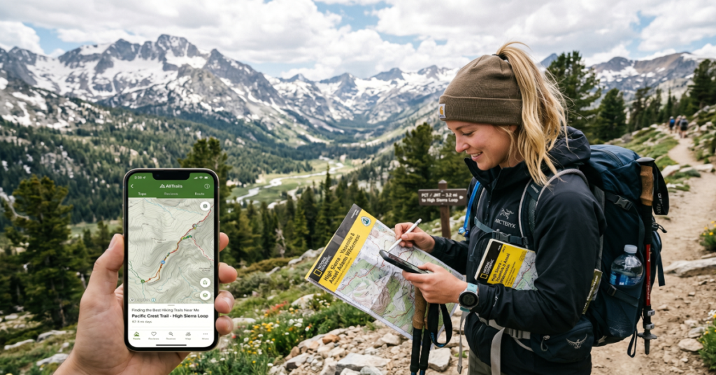
Searching for hiking trails near me has become far more sophisticated than typing a phrase into Google Maps. Most modern hiking platforms now combine GPS data, topographic mapping, weather overlays, elevation profiles, and real-time user reviews to deliver location-specific trail recommendations across the United States.
For beginners, that means quickly finding easy loops with parking, restroom access, and family-friendly terrain. For experienced hikers, it means filtering routes by elevation gain, scrambling sections, water crossings, or backcountry permits. Apps such as AllTrails and onX Backcountry have transformed trail discovery into a data-driven experience rather than guesswork.
The demand for local outdoor recreation surged after 2020, and that growth continues. According to the Outdoor Industry Association, hiking participation in the US has remained elevated compared with pre-pandemic levels, increasing pressure on popular trails while also driving investment in digital trail infrastructure.
The challenge today is not finding trails. It is finding the right trail for your fitness level, weather conditions, available daylight, and navigation confidence. That distinction matters. Many injuries on US trails happen not because hikers lack enthusiasm, but because they underestimate terrain complexity, elevation gain, or changing conditions.
This guide breaks down the best tools for finding local trails, compares major hiking apps, explains practical route-planning strategies, and highlights well-known US hiking destinations that consistently deliver reliable experiences for different skill levels.
Why “Hiking Trails Near Me” Searches Work Better Today
Ten years ago, local hiking discovery depended heavily on regional guidebooks, visitor centers, and static websites. Today, smartphone GPS systems continuously refine nearby recommendations based on your movement patterns and current location.
Three major changes reshaped the experience:
GPS Precision and Offline Mapping
Modern hiking apps use downloadable offline maps that remain functional even without cellular coverage. This has become critical in mountainous regions where reception drops quickly.
Field testing by backpacking reviewers at Backpacker Magazine consistently shows offline navigation reducing route-finding mistakes during poor visibility and winter conditions.
User-Generated Trail Intelligence
Crowd-sourced updates often appear faster than official park alerts. Hikers frequently report:
- Fallen trees
- Seasonal flooding
- Snowpack depth
- Wildlife sightings
- Parking limitations
- Mud conditions
This real-time information can materially change route safety.
Terrain Data Layers
Apps increasingly integrate:
- Elevation heat maps
- Slope gradients
- Avalanche zones
- Fire history
- Satellite imagery
- Public land boundaries
These features matter particularly in western US states where trails frequently cross federal, state, and private land boundaries.
Best Apps for Finding Hiking Trails Near Me
The strongest hiking platforms each solve different problems. No single app dominates every category.
| App | Best For | Key Strengths | Potential Drawbacks |
| AllTrails | Casual and intermediate hikers | Huge trail database, reviews, offline maps | Some crowded trail recommendations |
| onX Backcountry | Advanced route planning | Land ownership maps, terrain overlays | Learning curve for beginners |
| TrailLink | Easy and rail-trail routes | Accessible paved paths | Less backcountry coverage |
| National Park Service | Official park information | Closures and permit accuracy | Limited personalization |
Comparing Popular US Hiking Trails
Some trails consistently appear in recommendation algorithms because they balance scenery, accessibility, and infrastructure.
| Trail | Location | Difficulty | Length | Primary Appeal |
| Superior Hiking Trail | Minnesota | Moderate | 310 miles total | Forests and Lake Superior views |
| Bright Angel Trail | Grand Canyon, Arizona | Moderate to Hard | 9+ miles | Canyon descent experience |
| Mobius Arch Loop | Alabama Hills, California | Easy | 0.6-mile loop | Desert rock formations |
| Big Trees Trail | Sequoia National Park | Easy | 1.3-mile loop | Giant sequoia access |
Bright Angel Trail
The Bright Angel corridor remains one of the most searched national park hikes in America. Rangers at National Park Service repeatedly warn that many visitors underestimate heat exposure during the return ascent.
One operational insight rarely discussed in generic hiking articles: downhill sections create false confidence. Most emergency calls occur during the uphill return when hydration and energy reserves collapse simultaneously.
Superior Hiking Trail
The Superior Hiking Trail demonstrates how long-distance trails increasingly benefit from app integration. Section hikers can now track shuttle access, water sources, and campsite reports in near real time.
This matters because long-distance trail logistics, not fitness alone, often determine trip success.
How GPS-Based Trail Search Actually Works
Most “near me” trail apps rely on several combined systems:
- Smartphone GPS positioning
- OpenStreetMap trail datasets
- Government GIS land databases
- User-uploaded GPX tracks
- Satellite imagery
- Elevation modeling
A common misconception is that every trail inside an app has been professionally verified. Many have not.
That creates an important trade-off:
- Large databases increase discovery potential
- Larger databases also increase mapping inconsistencies
Experienced hikers often cross-reference routes between multiple sources before committing to unfamiliar terrain.
Hidden Risks of Over-Reliance on Hiking Apps
The convenience of digital navigation introduces new problems.
Battery Dependency
Cold temperatures dramatically reduce smartphone battery life. The National Park Service regularly advises hikers to carry physical backup navigation tools for remote routes.
Crowd Amplification
Apps can unintentionally “viralize” fragile trails. Locations once known primarily to locals may experience rapid traffic increases after trending in recommendation feeds.
Several western US parks have already implemented permit caps due to infrastructure strain and ecological erosion.
Difficulty Inflation
User reviews are subjective. A trail labeled “moderate” by experienced hikers may feel extremely demanding for casual walkers unfamiliar with sustained elevation gain.
One practical workaround used by seasoned hikers is comparing elevation gain per mile rather than relying on app difficulty labels alone.
Best Beginner Hiking Trails in California
California remains one of the strongest states for beginner-accessible hiking because of climate diversity and park infrastructure.
Big Trees Trail
This trail combines short distance with high scenic value. The paved and boardwalk sections also make navigation straightforward for families and older visitors.
Mobius Arch Loop Trail
The Mobius Arch Loop became especially popular among photographers because of its framing view of the Sierra Nevada mountains.
An overlooked benefit is its low physical barrier to entry. Many scenic western hikes require aggressive elevation gain. This one does not.
Pinnacles National Park
Pinnacles loops increasingly appear in “near me” recommendations for Central California users because of improved mobile coverage and updated trail data integration.
The park also offers strong beginner wildlife visibility, particularly for California condors.
How to Use AllTrails More Effectively
Many users only scratch the surface of what the platform can do.
Filter by Elevation Gain, Not Distance
A four-mile hike with 2,000 feet of elevation gain is significantly harder than a flat eight-mile route.
Download Maps Before Arrival
This is essential in national forests and canyon systems where reception disappears quickly.
Read Recent Reviews First
Trail conditions change weekly due to weather, snowmelt, or maintenance work.
Cross-Reference Official Park Alerts
Apps are useful. Official agencies remain authoritative for closures, wildfire restrictions, and permit requirements.
National Park Trails vs Local Trail Networks
National parks dominate online visibility, but many local and state trail systems provide better accessibility and lower congestion.
| Trail Type | Advantages | Limitations |
| National Park Trails | Infrastructure, scenery, ranger support | Crowding, permit systems |
| State Park Trails | Lower traffic, easier access | Variable maintenance |
| Urban Greenways | Accessibility and convenience | Less wilderness immersion |
| Rail-Trails | Beginner-friendly surfaces | Limited elevation challenge |
One emerging trend is the growth of rail-trails. Platforms like TrailLink have capitalized on demand for accessible outdoor recreation among walkers, cyclists, and families.
Safety Tips for Appalachian Trail Sections
Appalachian Trail
Even short Appalachian Trail sections require planning discipline.
Experienced section hikers consistently emphasize:
- Carrying extra water beyond estimates
- Monitoring ridge weather patterns
- Understanding shelter spacing
- Starting early during summer heat
- Packing insulation layers even in warm months
One field observation from long-distance hikers: beginners frequently overpack food while underpacking water management systems.
That imbalance becomes noticeable during humid eastern climbs where dehydration develops gradually rather than dramatically.
The Cultural Impact of Hiking Apps
Digital trail discovery has changed outdoor culture itself.
Previously, route knowledge was often local and community-based. Today, algorithmic visibility heavily influences where people hike.
This creates both opportunity and tension:
Positive Effects
- More people access public lands
- New hikers gain confidence
- Safety information spreads faster
- Smaller parks gain visibility
Negative Effects
- Social media congestion spikes
- Parking infrastructure overload
- Habitat degradation
- Trail erosion acceleration
Land managers increasingly face a balancing challenge between accessibility and conservation.
The Future of Hiking Trails Near Me in 2027
By 2027, hiking discovery tools will likely become more predictive and environmentally responsive.
Several trends already point in that direction:
AI-Assisted Trail Matching
Apps are beginning to recommend trails based on previous pace, elevation tolerance, and weather preferences rather than simple distance filters.
Dynamic Environmental Warnings
Wildfire smoke, flash flood risk, and heat exposure modeling are becoming integrated directly into route planning systems.
Expanded Offline Functionality
As satellite connectivity improves, remote messaging and navigation redundancy may become standard even outside cellular networks.
Crowding Management Systems
National parks may increasingly integrate reservation systems tied directly into hiking platforms to manage congestion.
Still, infrastructure limitations remain real. Many trail systems already struggle with maintenance funding, parking capacity, and erosion control. Technology can improve navigation, but it cannot instantly solve land management constraints.
Key Takeaways
- Modern hiking apps dramatically improve local trail discovery but should not replace core navigation awareness.
- Offline maps are now essential equipment for serious hiking.
- Elevation gain often predicts hike difficulty more accurately than mileage alone.
- Official park alerts remain more reliable than crowd-sourced reports during emergencies.
- Rail-trails and state parks are increasingly important alternatives to overcrowded national parks.
- Trail popularity algorithms can unintentionally damage fragile ecosystems.
- Future hiking platforms will likely emphasize predictive safety and congestion management.
Conclusion
Finding the best hiking trails near me is no longer simply about proximity. It has become a layered decision involving terrain analysis, weather awareness, accessibility, crowd conditions, and digital navigation reliability.
Apps such as AllTrails, onX Backcountry, and TrailLink each solve different parts of that equation. Meanwhile, official resources from the National Park Service remain indispensable for closures, permits, and safety guidance.
The broader shift is cultural as much as technological. Hiking discovery has become algorithmic, immediate, and heavily influenced by crowd-sourced data. That accessibility helps new hikers explore public lands with greater confidence, but it also increases pressure on fragile landscapes already facing infrastructure and climate challenges.
The most effective hikers in 2026 are not simply the strongest or fastest. They are the most informed. Good route selection, preparation, and judgment matter more than any app interface ever will.
FAQ
What is the best app for finding hiking trails near me?
AllTrails remains the most popular general-purpose hiking app because of its large database and user reviews. onX Backcountry is better for advanced terrain analysis and land ownership mapping.
Are hiking apps accurate for trail difficulty?
Partially. Difficulty ratings vary because they rely heavily on user submissions. Elevation gain, trail surface, weather exposure, and altitude often matter more than the app label itself.
Can I use hiking apps without internet service?
Yes. Most major hiking apps allow offline map downloads. This feature is critical in remote national forests, canyon regions, and mountain terrain where cell coverage disappears.
What are the best beginner hiking trails in California?
Popular beginner-friendly options include the Big Trees Trail and Mobius Arch Loop Trail because they combine strong scenery with manageable terrain.
How do I safely hike Appalachian Trail sections?
Carry more water than expected, monitor weather carefully, and avoid relying solely on smartphone navigation. Many Appalachian sections involve steep climbs and limited emergency access.
Are rail-trails good for families?
Yes. Rail-trails are often paved or gently graded, making them accessible for children, casual walkers, cyclists, and mobility-limited users.
Methodology
This article was developed using publicly available data from official trail management agencies, hiking application platforms, outdoor recreation organizations, and field reporting from established outdoor publications. Trail characteristics, app capabilities, and infrastructure observations were cross-referenced against official National Park Service resources and platform documentation.
The analysis also incorporated documented hiking safety guidance, outdoor participation trends, and user workflow observations reported by experienced backpacking and trail-planning publications.
Limitations exist. Trail conditions change rapidly due to weather, wildfires, maintenance, and seasonal closures. App interfaces and subscription models also evolve frequently. Readers should always verify current conditions with official land management agencies before beginning any hike.
References
- Outdoor Industry Association. (2024). Outdoor participation trends report. Retrieved from https://outdoorindustry.org
- National Park Service. (2025). Hiking safety and trail information. Retrieved from https://www.nps.gov
- AllTrails. (2026). Trail discovery and navigation platform overview. Retrieved from https://www.alltrails.com
- onX Backcountry. (2026). Backcountry mapping and GPS navigation tools. Retrieved from https://www.onxmaps.com/backcountry/app
- TrailLink. (2026). US rail-trail and pathway database. Retrieved from https://www.traillink.com
- Backpacker Magazine. (2025). Best practices for offline navigation and trail safety. Retrieved from https://www.backpacker.com